
Success Story: Illinois State Water Survey
From Invisible to Visible: Digitizing Groundwater Data
The Illinois State Water Survey (ISWS) is a division of the Prairie Research Institute at the University of Illinois. The Water Survey’s scientists conduct state-of-the-art research and collect, analyze, archive, and disseminate high-quality, objective data and technical information. The Water Survey’s data, services, and expertise provide a sound technical basis for the people and policymakers of Illinois to make decisions.
ABOUT ILLINOIS
STATE WATER SURVEY
Figure 1: From 1895 – present, reporting evolved from mailed or phoned in reports every ten years, to annual reports and are transitioning to all-digital, more frequent data
On March 22nd, 2022, the United Nation’s World Water Day will focus on an underdiscussed, but very timely topic – Groundwater. Guided by this year’s theme ‘Making the Invisible Visible’, the UN aims to “draw attention to the hidden water resource that has always been critically important, but not fully recognized in sustainable policymaking.” This article discusses how the digitization of groundwater data improves the visibility of groundwater for everyone’s benefit.
AT A GLANCE
How long can our water supply last? What question is more essential to our survival? How do we know the answer? Let’s look at how this fundamental question is addressed in the State of Illinois.
In 1895, the Illinois legislature tasked the University of Illinois with being the source of truth for the water demands of communities and the available water supply across the state. What they started, evolved into the current Illinois State Water Survey (ISWS), a division of the Prairie Research Institute. The Groundwater Science section conducts research, collects and analyzes data, and is the central repository for water supply and demand information critical to Illinois residents.
From its inception to the 1960s, the ISWS conducted a survey every ten years for each high-capacity point of water withdrawal and use. The data has become more specific over the years with advances in hydrological, geological and water use knowledge.
In 1972, Congress enacted the Clean Water Act, establishing the basic structure for regulating discharges of pollutants into US waters, and regulating quality standards for surface waters. Five years later, amendments to the Clean Water Act authorized the U.S. Fish and Wildlife Service to assist states in developing best management practices in their large-scale water pollution control programs. Water stewardship was in the spotlight. In 1978, a voluntary reporting program was initiated to report annually what had been reported every ten years – the Illinois Water Inventory Program (IWIP), which became mandatory in 2010 for Public Water Suppliers and Self-Supplied Industry water users, followed in 2015 for Agricultural Irrigation water users.
PROBLEM ADDRESSED

Going Digital
Until as recently as 2018, the state’s groundwater survey data was gathered chiefly through traditional mail, with additional support via phone interviews and emails. The ISWS developed an internal system which involved keying in data from the thousands of past paper reports stored in file cabinets. This gave them the opportunity to analyze and model past data. ISWS scientists were then able to see trends more quickly with the more frequent annual data provided via an on-line tool developed to replace the paper system. In many instances, with growing population comes increased business and farming, which puts greater demands on available water resources. For the ISWS and Illinois communities, it is crucial to know the timing and location of aquifer decline in order to project how a given population will be affected.
Why is More Frequent Data Important?
While the legal mandate for data collection is limited to annual reporting, more frequent data can show valuable trend details that can make a massive difference in the forecasted availability of a water supply. The ISWS has regional partners around the state that exchange studies with them and rely on them for lifespan forecasts of their water supplies. Among the questions asked: “What is the maximum amount of water that we can sustainably pump from our aquifer?” For regional partners in Northeast Illinois, groundwater withdrawals become unsustainable when the deeper sandstone layers become dewatered. As an aquifer approaches the end of its lifespan, little details make a big difference, and little details go unnoticed with annual data collection.
For example, how productive are the wells? To know this, you need to know the static level of a well, the level when pumping, the difference between those two, then divide the result by the well’s pumping rate (engineers call this the specific capacity). Declines in specific capacity imply that more drawdown occurs when the well is pumping, shortening forecasts of sustainable use. Knowing the daily use of the wells gives water users far more information on the life of the supply than annual reporting required by IWIP.
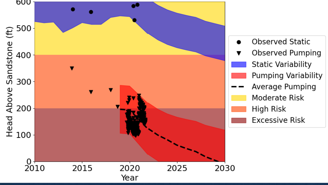
The City of Joliet, Illinois, facilitated a pilot project that provided monthly data to the ISWS to assess local and regional water supply. In 2019, Joliet officials were instrumental in organizing the Southwest Water Planning Group, a coalition of communities and industries that use a shared and heavily stressed groundwater resource - the deep sandstone aquifer. The data brought to light trends that were insightful to ISWS researchers and changed how the region viewed its water resource. The actual observed groundwater levels changed significantly throughout the year at many facilities, an observation not apparent from just looking at the annual numbers. At the facility shown in Figure 2 above, peak demands result in heads falling into the “Excessive Risk” zone, with great uncertainty whether this well will be able to extract water over the next eight years. The year 2030 is key for many at-risk wells in the region, because Joliet (the largest water user in the region) intends to find an alternative source by that date. Even still, modeling indicates that when Joliet switches off the aquifer, many communities and industries will still have at-risk water supplies, particularly during peak pumping conditions. These peak pumping conditions could only be evaluated by efforts to collect monthly data.
Digital Advances towards Real-Time Data
According to Dr. Daniel Abrams of the ISWS, “if we had monthly pumping data as well as monthly water level data, we would be able to understand more of the variability between observed and estimated water levels.” In addition, ecological impacts are often greatest during peak conditions. As communities struggle with droughts and increase pumping throughout a drought period, changes to the aquifer levels and water quality become more critical. This points up the need for greater frequency of data.
Sensing the need to leverage technology to move toward more precise data, ISWS, led by Steve Wilson and Vlad Iordache, collaborated with Illinois-based water sector operations data analytics company, Waterly, a digital platform supported by WaterClick, for near real-time water pumping data in a pilot with ISWS and several communities in Illinois. Monthly (or more frequent) data would be a huge improvement to the team’s ability to forecast aquifer changes, and as a subset of high-capacity public users report daily data to EPA, this new system can use that data for ISWS. As Illinois EPA requires that information on paper, the platform developed by Waterly is critical to capturing the digital information for ISWS, as well as unlocking potential distribution related challenges.
SOLUTION(S) USED
SUMMARY
Automated retrieval of groundwater data allows ISWS to stay updated on groundwater levels and potential risk indicators for communities.

Monthly or real-time data enables regulatory agencies, research organizations, and communities alike to improve their understanding of current and future water risks.

Digitization of waterworks supports the sustainability and resilience of groundwater supplies.

LESSONS LEARNED
From large metropolitan areas to the suburbs, frequent groundwater data is crucial to the ability to plan for resiliency, economic growth, and public health.
Figure 2(left): Observed and simulated decline in static and pumping heads at an at-risk deep sandstone well. High frequency data collection at this well illuminates the variability in water levels and uncertainty in the remaining lifespan of this well.
Figure 3(right): From ISWS – Trillions of gallons of water demand information has flowed through this room daily for approximately 50 years.

Figure 4: A trend of historical groundwater static water depth data for West Dundee, IL generated from Waterly's simple groundwater management module.

South Elgin, West Dundee, Joliet, McHenry County are now piloting groundwater pumping data collection and have near real-time data as a result.
“Watching the transformation from old-school paper forms to seeing the potential of the data being available at the aquifer or state level near real-time has been awesome. What used to take a year for the state to see and days for us to compile is just starting to be done directly from the field as often as we are collecting well data.”
Nick Gornick
Deputy Director - Plant Operations
City of Joliet, IL
Waterly is currently piloting groundwater pumping data collection with South Elgin, West Dundee, Joliet, McHenry County, Arbury Hills and others in an exciting public-private partnership with ISWS. Long-term, having monthly or possibly real-time data, such as the data provided through the Waterly software, will enable the ISWS to improve their understanding of current and future water risks across the State of Illinois. From large metropolitan areas like Chicago to the suburbs, small towns, farms, and major industrial users, frequent groundwater data is crucial to the ability to plan for resiliency, economic growth, and public health. Strategic public-private partnerships like the Waterly-ISWS project are a prime example of how the digitization of water works to support the sustainability and resilience of groundwater supplies.